Heathland Restoration Project 2019 -
Project Updates - Click below to view or scroll down to read the project overview
February 2022 Update
January 2022 Update
December 2021 Update
November 2021 Update
October & November 2020 Update
March 2020 Update
February 2020 Update
January 2020 Update
December 2019 Update
November 2019 Update
October 2019 Update
Project Background
With the support of Forestry England, the Cannon Hill Friends are carrying out this project to restore a section of lowland heath.
A small section of Uddens Plantation that was felled prior to 2009 has since proved to be unsuitable for reuse as timber crop, with the current Scots pine struggling to thrive.
It would however make a suitable site to re establish as the scarce and ecologically valuable lowland heath.
There is already evidence of heathland species such as heather gaining a foothold here.
The site also makes an ideal stop off point between Holt Heath, Slop Bog and Ferndown Common.
Dorset Heathland, itself a man made environment, dates back to the Bronze age.
In more recent times it has come under pressure from timber growing, urban development and agriculture.
Dorset Heathland Species
Some of the scarcer species that Dorset Heathland can support includes Dartford warbler, nightjar, woodlark, sand lizard, smooth snake, ladybird spider, Purbeck mason wasp, southern damselfly, marsh gentian and Dorset heath.
Get Involved!
We will be on site from 9am until 2.30pm on the following dates this year -
31st October, 14th November, 12th December, 9th January, 6th February, 6th March
For those around at lunch time, we will have our now legendary bonfire baked potatoes, served with beans and cheese.
Hot & cold drinks and biscuits available throughout.
Gloves, tools and training etc provided.
Ideally, please let us know if you are able to come along.
If you are under 16, please bring an adult with you. They are welcome to join in, or drink coffee and watch!
Let us know on arrival if you are completing your DofE award so we can keep the necessary records.
The ground conditions are a little challenging, so wear substantial footwear / wellies. The vegetation is likely to be wet if it has been raining, so you may want waterproof trousers.
Location Maps
To reach the sites, open the PDF's below
Closest access point is from the first entrance on the right on Uddens Drive, north of the A31 Ferndown Bypass.
Grid Reference SU 04997 01187
Parking is also available either side of the road 100 yards further up Uddens Drive.
Please keep the gateways clear for emergency access.
The work site is about 800 yards along the main track. (yellow line on the map)
We will put up some signs to follow.
|
| ||||
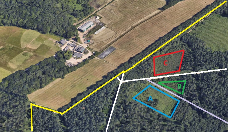
Aerial View
The Google Earth shot below (pre the solar farm instalation at Bedborough Farm), roughly shows the 3 project areas.
The yellow line is the Castleman Trailway.
The white line is the main gravel forest track.
The mauve line is a grass forest ride (track).
The yellow line is the Castleman Trailway.
The white line is the main gravel forest track.
The mauve line is a grass forest ride (track).